Sunday, June 23, 2013

Day 15 Mt. St. Helens & Gifford Pinchot Task Force

Today we drove to the Mt. St. Helens region to visit the Gifford Pinchot Task Force (GPTF), a small non-profit conservation group. They work with timber and wildlife issues, and more recently they are working on preventing a mining project behind Mt. St. Helens. This was the main topic of discussion today. Ascot Resources is trying to do exploratory drilling for gold, malyptinum, and copper right behind the Mt. St. Helens crater. This area is in a public forest on the very edge of the National Monument, and about 12 miles from the Crater. A Canadian company purchased the rights to this land; they own 50% and the National Forest Service owns the other 50%, which is a public interest.
Mining in this area presents serious environmental problems because the site is right next to the Green River, which is the headwaters for a watershed used for drinking. The area is also covered in old growth forest and there isn't much of that left after the eruption. Unfortunately, they are able to go in and do exploratory drilling without much environmental oversight. They drilled 15 holes with no environmental assessment. I couldn't believe that! In 2011, the company wanted to do more drilling but the GPTF filed suit in Federal District Court asking for a full review. The Forest Service pulled the permit and an environmental assessment was completed. However, there was no baseline water assessment completed because they said there were wells drilled in the 1970's that weren't affecting the river so that must mean it won't affect it now either. They didn't actually do a study, they are just speculating and saying that there must be a fault line there so the water isn't an issue. I was completely blown away by this. I cannot believe that they would allow such ridiculous reasoning for something so important. Thankfully, the GPTF is on top of them and they found a similar situation that occurred in Idaho where they said they can't do anything without a baseline, so they're using that example in court. Their argument is that the drilling and mining is not compatible with the primary purposes for which the land was acquired. Those purposes are: protecting the integrity of the Green River, the scenery of the Mt. St. Helens portal, outdoor recreation, habitat needs for local endangered species, and timber production and preservation of the watershed. Drilling in this area would use more than 5,000 gallons of water per day, introduce harmful chemicals, and destroy habitat. Not to mention, the area is generally unstable and there is still seismic activity. The GPTF is still fighting in court; they're waiting for them to decide whether they're going to pull their permit or continue this summer.
I couldn't believe that they would let companies drill in that area when it is still seismically active. I also couldn't believe that they were drilling without a baseline study. Then when she said the "study" was just speculation from the 1970's I was shocked! I don't understand how they get away with that. They don't actually know anything about the aquifer that they're drilling over and threatening the drinking water. I also thought it was strange that there's tons of pages missing from the original Duval reports in the 1960's-1970's. Something else seems to be going on. I think they should do another survey, especially becase they have new and advanced equipment now. I also think that they need an independent study to be done. I hope that they win the case and they don't end up mining there. Hopefully they can add the area to the National Monument and protect the Green River as well. I enjoyed this talk because she explained the topic very well and I learned a lot. I had no idea how much politics went into mining and the loopholes that exist within the process.
After our talk, we drove up to check out Mt. St. Helens. It was so much more beautiful than I ever imagined. When you hear about the eruption, you think it is going to be barren and ugly. There were still trees blown down from the explosion, but the vegetation is growing back in most places. My favorite park of Mt. St. Helens was Johnston's Ridge Observatory, where a scientist lost his life in an attempt to study the 1980 eruption. It is so close, you feel like you can almost touch the crater. The wildflowers growing were gorgeous. I wish we could have stayed there for longer; it was such a cool place.

A view of Mt. St. Helens Johnston Ridge Observatory
Tonight we stayed at the Spring Hill Suites Marriot in Vancouver, WA. We got to go in the pool and the hot tub for a little bit, which is always exciting. The rooms were beautiful and we had a nice stay. It's always nice to have a hotel after a few days of roughing it. Tip: Swim every chance that you get! Even if it's just for a few minutes. You'll be happy you did.

Saturday, June 22, 2013

Day 14 Olympic National Park- Forestry

Patrick speaking about forestry
This morning we were driving through BLM land and saw some sectional cutting. We stopped and Patrick talked about the US Forestry Service and logging. The USFS was created to regulate logging and make sure it was done in a sustainable way, taking things like density and health of the forest into account to make decisions about where to cut. The USFS is criticized often because they don't bring in as much money as they spend, and they don't enforce as much as they should.
Patrick explained that the sectional cuts we were seeing is more sustainable and leads to more biodiversity and successional growth, which is good for the forest. It also minimizes soil loss, landslides, and it protects trees from wind damage. Without any cutting, the forest would be too dense. This is a problem because it leads to high fuel for wildfires and makes trees more vulnerable to bugs and diseases.
When logging in a national forest, trees must be replanted. However, about 1/3 or more don't get replanted. They seem to only replant in high visibility areas, such as along roads. This was upsetting news, I thought that the USFS was doing a good job. I was pretty disappointed by this. I hope that they start enforcing the rules for replanting.
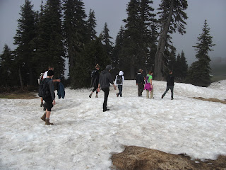
Hiking up the mountain!
We drove through Olympic National Park and went for a hike up the mountain in the clouds. It was so cool to be hiking in the snow in the morning, and then swimming in the Pacific Ocean by the afternoon! I couldn't believe it! When we drove to the shore it was simply breathtaking; I was in awe. We did a mini hike through this temperate rain forest and it was like a jungle. Then, all of the sudden, there it was. The Pacific Ocean! I couldn't believe it. It was like something out of a movie. The little islands in the water were harder rock than the rest of the shore, so it hasn't eroded as much.


First Beach
They were really cool looking and I was thinking about what kind of birds and bugs must live there in the trees. It was also interesting how many trees were washed up on the shore. Tait explained the techtonics of the area and I didn't realize that Olympic wasn't part of the Cascades. I also thought it was interesting that the amount of rainfall here supports distinct flora and fauna in the area. There is more biomass here than anywhere in the world, and I thought that was awesome.


Rialto Beach

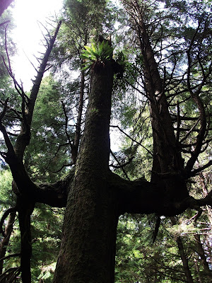
Patrick explained that this tree was probably struck by lightening or had some other disturbance that caused this terminal trunk to form. This is a somewhat rare phenomenon.

Friday, June 21, 2013

Day 13 Olympic National Park- Salmon & Dam Removal

Patrick gave a great lecture today about Salmon and dam removal. Salmon are considered a keystone species because they have an important impact on multiple trophic levels. They are also an indicator species, meaning you can tell the overall health of the river ecosystem because they use the whole river system from the still water to the rapids. If the salmon are healthy, the river is healthy. The Endangered Species Act protects species, subspecies and distinct population species of Salmon. I thought it was interesting that one species can be protected in some areas and hunted in another. It is also possible for a type of salmon to be protected in one river and not protected in another river.
There are about 400 types of salmon in the Pacific NW, now only 200 remain. This is probably due to the fact that there are 150 dams along the Columbia River. Salmon do not adapt well to this, or other activities that disturb their habitat such as logging. The "solution" to this is to create salmon hatcheries, but the salmon are not as robust and they don't do well. They are also creating competition between the native salmon, and the native populations are starting to actually decline. The state also tried to reduce harvest of salmon, but it is creating political problems.
We also spoke about Olympic National Park. Their goal is to preserve the Roosevelt Elk herd and old growth forest. This goal of conservation is somewhat unusual for the creation of a National Park, as it is usually founded on tourism. Olympic National Park has one of the largest undisturbed natural shorelines. The park is protected by the Wilderness Act, which means it is largely untouched by man, and it has opportunity for traditional recreational actives. There is no hunting, timber, or even pavement. I thought that was really interesting. One of the challenges is that a lot of people want to hike at Olympic so it's hard to keep the area pristine.
The Elwah Dam was built in 1912 without a permit and was inside of the Nat'l Park with the unique mission statement to protect the area... yet there was a dam upstream. After years of debate, it was finally decided that it was not economically viable to update the dam, and it would be beneficial to the salmon if it was removed. Lots of sediment was released after the removal, which harmed the river for some time, but it was unavoidable. It will take at least ten years to restore the river to somewhat natural conditions. The removal gave many opportunities for scientists to study the impacts of dam removal on the river. It is also a model of how to rebuilt habitat. I was surprised to learn that after dam removal, it takes over 100 years for it to be visibly back to normal, if ever, I didn't realize it takes so long for the ecosystem to fully bounce back. I am interested to watch and see how the Elwah is restored over time, and what kinds of strides will be made in other dam removals from to the knowledge we gain from Elwah.
Our Campsite along the Elwah River

Thursday, June 20, 2013

Day 12 Mount Rainier

Last night we stayed at the Red Lion Hotel, and some of us took a cab to Seattle to go check it out and have some dinner. It was Lucia, Jess, Bienchy, Katie, Craig, Billy and Cody. We walked around for a while until we met a local who told us to go to this restaurant down the street called Lecosho. It was beautiful; there were candles and a big bench seat with pillows. We ordered a bunch of food to share. I got the rib ends and it was the best piece of meat I've ever had. We all had such a great time together. It was one of my favorite memories of the trip for sure. This morning we took the vans for an oil change and then we picked up Patrick and Susan from the airport in Seattle. Next we drove to Mt. Rainier and there were foggy clouds hanging low in the mountains, it was really cool. We stopped at the visitor center and then went for a hike on the Wonderland Trail. We lost part of the group and ended up getting some extra exercise trying to find them. Tip: If you ever get lost, STAY PUT! This seems to be a reoccurring trend.....
I loved the hike anyway because the old growth forest was so majestic and beautiful. I've never seen trees so tall in my life. Everything was so green and glowing with life. After we found the rest of the group, we went up to check out Crater Falls, which was very beautiful. It was raining, but we didn't care. It just added to the mysteriousness.


Afterwards, we drove to "The Lodge" near Mount Rainier. It was a big old house, and Tait said it was haunted. It was so big and cozy inside; it had a lot of character. We had a nice dinner together and Tait tried to make me eat his MRE meal that he didnt put hot enough water in. It was pretty funny. Then we had a discussion about Libby and Mt. Rainier. A few of us stayed up to make a fire in the fireplace and we had a few good laughs. I really love this group and I'm so glad to be able to get close with them. I made some really good friends here so far and I'm having a great time.


Mount Rainier National Park is in western central Washington. It is 99% wilderness, which is uncommon. I was fascinated that the area receives between 120 to 600 inches of rain per year and 80 feet of snow on the mountain. The two biggest glaciers are Carbon Glacier and Emmons Glacier. The problem is that they are melting much faster than glaciers in Glacier National Park. The amount of rain they receive here might have something to do with it. Or, it could be because there is less light being refracted back out into space due to the tree cover. We also talked about the fact that the forest is extremely dense, and it is creating fuel for a potential fire that would be devastating to the region.

Wednesday, June 19, 2013

Day 11 Hanford Site

Today we drove to go check out the Hanford Nuclear Site to learn about the progress and clean up. Erica Holmes, from the department of ecology, gave a presentation with an overview of the site and what they are working on to clean it up. Hanford is home to the worlds first plutonium-production facilities built during WWII as part of the Manhattan Project. The site is 586 square miles and contains 50 miles of the Columbia River, which is a major environmental issue. In general, the Department of Energy was not very concerned about byproducts when the site was built and production was underway for WWII. Ironically, the Columbia River is part of the reason why this site was chosen in the first place. They needed an area with an available water source for production and to cool the reactors. The site was also chosen based on the rocks available to make concrete, and an abundant area for the site, and the low population in the area. People were given 30 days to leave under the War Powers Act, which I found very interesting. (Click here to visit my page about the history of Hanford.)
The Department of Ecology's role at Hanford is to ensure that the clean up protects the Columbia River by following state laws to protect the air, land, and water. Their goal is also to protect and preserve the environment. Erica explained some of the cleanup challenges they are faced with at Hanford. First of all, there were no environmental requirements when the site was built. As a result, 450 million gallons of waste was dumped onto the ground, and there is 56 million gallons of waste in 177 underground storage tanks. The activities on the site lead to about 72 million square miles of groundwater being contaminated. There are also political challenges, such as the federal budget of $112 billion for the life of the site. This raises questions like, "What is the risk reduction per dollar spent?", "Why is it taking so long?" and "How does Hanford rank versus other priorities?"
So far they've stopped liquid discharges into the soil, removed 14 million tons of soil, and removed pumpable liquids from 149 single shell tanks. They are planning on having the groundwater cleaned up by 2024 and they are recording soil and water samples to better define the problem so that we can have a plan. There are about 1000 wells sampled per year and biota are also sampled routinely. The main priority is cleaning up the groundwater and soil to protect the river. They also want to finish the plant demolition. The primary remediation technology they are using is vitrification, which entails heating the waste and turning it into glass. This is one of the safeest way to store hazardous waste. Unfortunately, they are not capturing energy through the vitrification process, though. That was a little bit disappointing to hear. The overall theme of the cleanup is to exhume waste and consolidate it into engineered storage that is safe for long-term. This is the best that we can do.
I thought that the presentation gave a bit of a limited view of the Hanford site. I wish they went into the details of what is going on there with the clean up. I was excited to learn more about the remediation technologies used. I did learn a lot about the challenges they faced, including policy and technological issues. I thought it was really interesting that they said another challenge is that they don't have enough skilled engineers and we need more classes to teach people these skills. I was shocked about the number of chemicals (1800) and unknown chemicals (20) that are in the soil. I was surprised to learn that the workers are more scared about these chemicals than radioactive waste. That put things into perspective for me a little more.
After the Hanford site, we stopped to check out the Wildhorse Windfarm. This facility is located near Ellensburg, Washington and is about 10,000 acres. It has 149 turbines that generate 273 MW of electricity. It was built in 2006 and expanded in 2009. Wildhorse is also home to one of the Pacific Northwest's largest solar-power arrays. The facility benefits the local community by providing affordable alternative energy as well as creating jobs and local tax revenue.

Tuesday, June 18, 2013

Day 10 Libby, Montana

We drove to Libby, Montana today to try to go see the mine. Unfortunately, they did not allow us to enter because it was too dangerous. Meanwhile, there is a whole town of people still living there. Let that set the premise for this blog.
We ended up meeting at a small park to talk about Libby and the problems with asbestos. Asbestos is a fibrous material that is strong, long-lasting, and heat resistant, which has led to its use in thousands of products. Asbestos causes acute effects such as asbestosis from the fibers getting into the lungs, and chronic effects like lung cancer occur after about 15 years. Long term exposure (25-40 years) to asbestos causes mesothelioma.
There are two rocks associated with asbestos: serpentine and chrysotile. The most common is the form that comes from serpentine. The kind of asbestos in Libby is called amphibole asbestos. It is not a commercially viable mineral, but rather a contaminant in the vermiculite ore found in the Libby mine. Amphibole asbestos breaks apart more easily, and is believed to be more toxic than other types of asbestos. Granite rock was the base for vermiculite and it also contained tremolite and actinolite as impurities. Vermiculite was discovered in Libby in 1881, and in 1919 it was found that vermiculite "popped" when heated, which created pockets of air and made the material suitable for insulation or as a soil additive. By 1940, between 70-80% of all vermiculite in the world was mined from Libby. Zonolite industries knew all of the problems with asbestos and they chose to hide it from the public. When people got sick, they just transferred them to a different job in the mine that's less work- they didn't want to put people on disability because they didn't want whistle-blowers. W.R. Grace bought the company, and they chose to hide information about cancer as well. Eventually, 1 in 40 people in town had an asbestos related disease. W.R. Grace started tracking from 1973 to 1990 there were 88 reported deaths. Bad press in the 1980's led to the decline in demand for asbestos, and the mine was shut down. This is also when lawsuits really began popping up.
Citizens petitioned for the site to be designated a Superfund site, and W.R. Grace was named the responsible party. in 2005, EPA took 7 people from W.R. Grace and charged them with criminal charges, but they were dropped. (I was kind of shocked to hear this.) They removed 900,000 square feet of soil in the area and 1500 houses had to be cleaned. There were hot spots near fields, schools, and the mines, but really it was everywhere; people even used it in their gardens and driveways. We also watched a documentary about the clean up process and how upset people were about having people come in their homes. Emotions run high in Libby, and the community is somewhat skeptical of the EPA. Some people left town, but most stayed. They started logging and doing other things, so life went on in Libby. Unlike Anaconda, Libby had logging to fall back on so they were able to stay and continue to make a living in Libby. Anaconda did not have a secondary resource, and they didn't really bounce back.

Monday, June 17, 2013

Day 10 Apgar Campsite at Glacier Nat'l Park

Last night, Craig and Jess got sick. It was really a bummer. We were all pretty freaked out and we were trying to figure out where it came from. Thankfully, they felt a little better this morning, but they still seemed exhausted. Kudos to them for sticking it out and coming hiking! We are troopers!!!
During our hike, we stopped to talk about how the river looks green because of the reflection from the forest. I didn't know that and I thought it was really interesting. We learned that the park is a temperate rain forest- vegetation covers about 80% of the forest floor, and the leaf litter and organic matter that falls on the ground takes a long time to decompose. We also stopped to talk about a tree that had fallen due to its shallow roots and the wet soil.
Before we came to Glacier, we learned about how it was formed and how it became a National Park. Glacier National Park was combined with Canada's Waterton National Park, and now it's Waterton Glacier International Park, or Peace Park. There are over 150 glaciers in the park that helped carve the landscape by moving and depositing material. The continental divide is here at Triple Point. The west is rich in moisture and can receive 120" of precipitation per year. On the east side, it warms up and the precipitation is only 20". This impacts where the glaciers and retreating. There are a number of issues at Glacier National Park. First of all, the glaciers are really tiny and inaccessible to people. They are retreating at an alarming rate, but there is no concrete documented evidence that shows that climate change is causing the retreat. Scientists started measuring some temperature changes 20 years ago, but we do not have enough data from enough years to make any conclusions. Another issue is that ozone is impacting the trees as well as the Crater Lake area. Trees are becoming more vulnerable to stresses like bugs, diseases, and drought.